Video summary
On August 20, 2026, the Santa Cruz Planning Commission convened with a full quorum to approve minutes from previous meetings and grant consent for a coastal permit involving two locations along West Cliff Drive, noting no significant environmental impacts. The primary focus of the session was on consolidated items addressing emergency repairs and road realignment projects necessitated by storm damage between 2023 and 2024. These initiatives included roadway and path repairs, sinkhole filling, sea cave infilling, coastal armoring such as seawalls and rock protections, and the replacement of the Bethany Curve culvert, with a specific project to realign a section of West Cliff Drive in Lighthouse Field to create an erosion buffer slated for construction in early 2027.
During the discussion, staff addressed public concerns regarding safety hazards from displaced riprap, potential impacts on beach sand, design aesthetics, and the ecological value of Lighthouse Field State Beach Park for wildlife like red-tailed hawks and monarch butterflies. Commissioners supported the projects while emphasizing alignment with the fifty-year West Cliff Adaptation Management Plan, which favors managed retreat over armoring where feasible, though a friendly amendment was adopted to incorporate future pedestrian and bicycle separation improvements within the approved scope when possible. Both items passed unanimously after considering necessary zoning permits, slope variances, and consolidated coastal permits from the California Coastal Commission, with mosaic panels on the new culvert subject to separate review by the Coastal Commission.
The meeting also featured updates on other city developments, including the City Council's approval of a housing project at 900 High Street, an upcoming zoning update package scheduled for September, and a completed community meeting for the Mission Street project attended by thirty residents. The Sustainability and Resiliency Subcommittee reported progress on West Cliff adaptation planning but highlighted scheduling challenges that unfortunately excluded a high school student member from one session, while a design guidelines survey remained open through late August. As the agenda items were concluded, the chair authorized moving forward to join another session, leaving the future status of the committee uncertain pending further discussions regarding its potential continuation.
Read the full video transcript
Good. All right. Thank you everyone for
your patience this evening as we had to
wait until we had full quorum. Um I'm
going to go ahead and call um today's
August 20th, 2026 meeting for the Santa
Cruz Planning Commission. U Tess, can
you go ahead and please call a roll?
>> Commissioner Paul Hamus
Gordon
Kennedy
>> here.
>> McKelie
>> here. Hammer Thompson
>> here.
>> Chair Kelly
>> here. Thank you. Um at this uh next
we're going to go ahead and do
statements of disqualification. Do any
commissioners have any disqualifications
disclosed for tonight's agenda items?
>> No.
>> All right.
>> No.
>> Fantastic. All right. I'm going to go
ahead and move to oral communications.
Oral communications is a time for
members of the public to go ahead and
speak uh to the commission on items not
on tonight's agenda. Um so if anyone
would like to speak on any items not
addressed tonight um and you wish to
speak,
please come on up.
All right, seeing none, I'm going to go
ahead and close oral communications.
All right, first item on our agenda is
the approval of minutes. Um, tonight we
have two items um to approve of. The
minutes for June 4th, 2026 and the
special planning commission meeting for
July 23rd, 2026. Are there any
commissioners who would like to make
corrections or comments on any either
set of minutes?
>> No.
>> All right. Anyone want to make a motion?
>> I move to approve both sets of minutes.
>> I second.
>> All right. With a motion on the floor,
um, all in favor say I.
>> I.
>> I. All right. Motion passes.
All right. The next item is uh item two
of uh and it is a consent item and staff
is going to go ahead and present a brief
explanation of the consent item for
tonight.
>> Yeah, I just wanted to uh mention I we
obviously have three items that are all
along Westcliffe um that are on the
agenda tonight. And so um some of the
reasoning for Westcliffe uh for that the
item that's on the consent calendar um
main reason being that different from
the other as you probably read the staff
reports a little more straightforward
project um where it's just basically
pulling in the the path um from the the
bluff retreat. Um couple differences
between the consent item and the other
two items is with the consent item um
we're issuing the coastal permit. It's
completely within the city's
jurisdiction. It's not in the coastal
commission jurisdiction. Additionally,
um it's in terms of SQA, there are no um
environmental impacts um and was
categorically exempt from from a SQA
standpoint. So, kind of the main
differences and so it's a little little
more of a straightforward project.
Therefore, that's why we we kept it on
the consent calendar.
>> Thank you.
Alrighty. Um so, yeah. So item two is
involving two locations along West Cliff
Drive. Um one on Lighthouse and then the
other one is on Lighthouse uh West Cliff
Drive and Gel Street. Um do any
commissioners wish to pull this item
from consent?
>> No.
>> All right. Seeing none, then um we can
go ahead and open to the public for any
comment. Does anyone want to make a
comment on the consent item for tonight?
All right. Seeing none, we'll go ahead
and bring it back to mission.
Commission, do you have any questions
that you'd like to ask staff or?
>> All right. Anyone want to entertain a
motion?
>> I move to approve the um the item as
written.
>> Seconded.
>> All right. Tess, would you like to do a
roll call
vote on that one?
>> Commissioner Kennedy,
>> I.
>> McKelie,
>> I.
>> Thompson,
>> I.
>> Chair Kelly,
>> I. All right, that motion passes.
All right. Uh the next item on the
agenda um are both are we are
consolidating items three and four for
tonight's hearing. Um so both items
three and four are concerned projects
along West Cliff Drive and because the
projects were reviewed under similar
process, the staff has consolidated the
presentation for these two items.
Uh, just pulling up the PowerPoint. One
second.
Okay. Uh, good evening, commissioners.
I'm John Jezik, associate planner with
the community development department,
and I'll be presenting two development
projects along West Cliff Drive tonight.
So, for some background, during 2023 and
2024, Santa Cruz experienced uh heavy
winter storms and atmospheric rivers. Uh
and these weather events generated large
waves uh which continually battered uh
the West Cliff Bluffs. Um and as an
effect of that, several sections of
these bluffs um as well as West Cliff
Drive itself and the pedestrian path
eroded into the ocean.
Um and so we have some pictures that
show that. So this is right under um
Lighthouse Field. You can see that a
part of the multi-use path collapsed
into uh the ocean.
And then this is a pretty good picture
too. This is um where the Bethany curve
bridge is. You can see that there's
significant portions of the multi-use
path and also the road itself that have
eroded into the ocean.
Uh so in response to that, the public
works department has worked with
governing bodies like the California
Coastal Commission, Regional Water
Quality Control Board, and the Army
Corps of Engineers to perform uh
emergency repairs for these storm
damaged areas along West Cliff. Um and
these emergency repairs have since
concluded and uh public works has
received formal approval from the
regional water quality control board and
the army corps of engineers and now
public works is requesting uh formal
approval from the city as well.
Uh so the first project is CP26-000092.
Uh this is the emergency repairs and
this location is roughly bounded by uh
920 and 10:30 West Cliff Drive. Uh seven
separate locations along that strip of
Westcliff Drive. Um and project
activities included repairs of the
roadway, uh repairs of the existing
multi-use path, and filling of a
sinkhole um underneath the parking lot
and also infilling of sea caves.
Um in addition to that there were
hardskate coastal armoring that was
added um that took the form of
engineered seaw walls, rock slope
protections and also um rip wrap.
Um and then also lastly the uh Bethany
culvert was damaged as part of these
storms and has since been um replaced as
part of this emergency work. Um and so
public works is requesting that the
planning commission formally approve um
all of that emergency work which has
taken place.
Um and the second project for
consideration tonight uh beyond the
scope of emergency repairs
um is a project to realign an
approximately 600 square foot section of
West Cliff Drive um and its associated
multi-use path. Um and this is located
um in the southwestern corner of
Lighthouse Field. And the public works
department is proposing to realign these
uh this rideway
um to provide a buffer from future
coastal erosion events.
Uh this work has not yet been completed
and if the planning commission approves
this project, construction is uh slated
to begin um in the early parts of 2027.
So, here's a kind of a brief view of
what that road relocation looks like.
Okay. In terms of permits required, um
both of these projects require the same
zoning permits and the same level of
review um at a public hearing with the
planning commission. The first one being
a design permit because the project
consists of public improvements in the
coastal zone uh pertaining to roads and
rights of way. Um the second one being a
variance to slope regulations. Uh the
project is located within 10 ft of a 30%
or greater slope which is the adjacent
Westcliff bluffs
and also a coastal permit. uh because
sections of both of these projects are
in the California Coastal Commission's
original jurisdiction which generally
starts seawward of the bluffs.
Um and the Coastal Commission indicated
that they will be processing one
consolidated coastal permit for the
entirety of these two applications.
And so planning staff has added a
condition of approval to the project um
requiring that the uh the public works
receive coastal commission approval um
prior to the start of construction.
And uh so the general format of these
next few slides are going to be um um
for each topic I'll be discussing the
emergency work first and then the road
relocation.
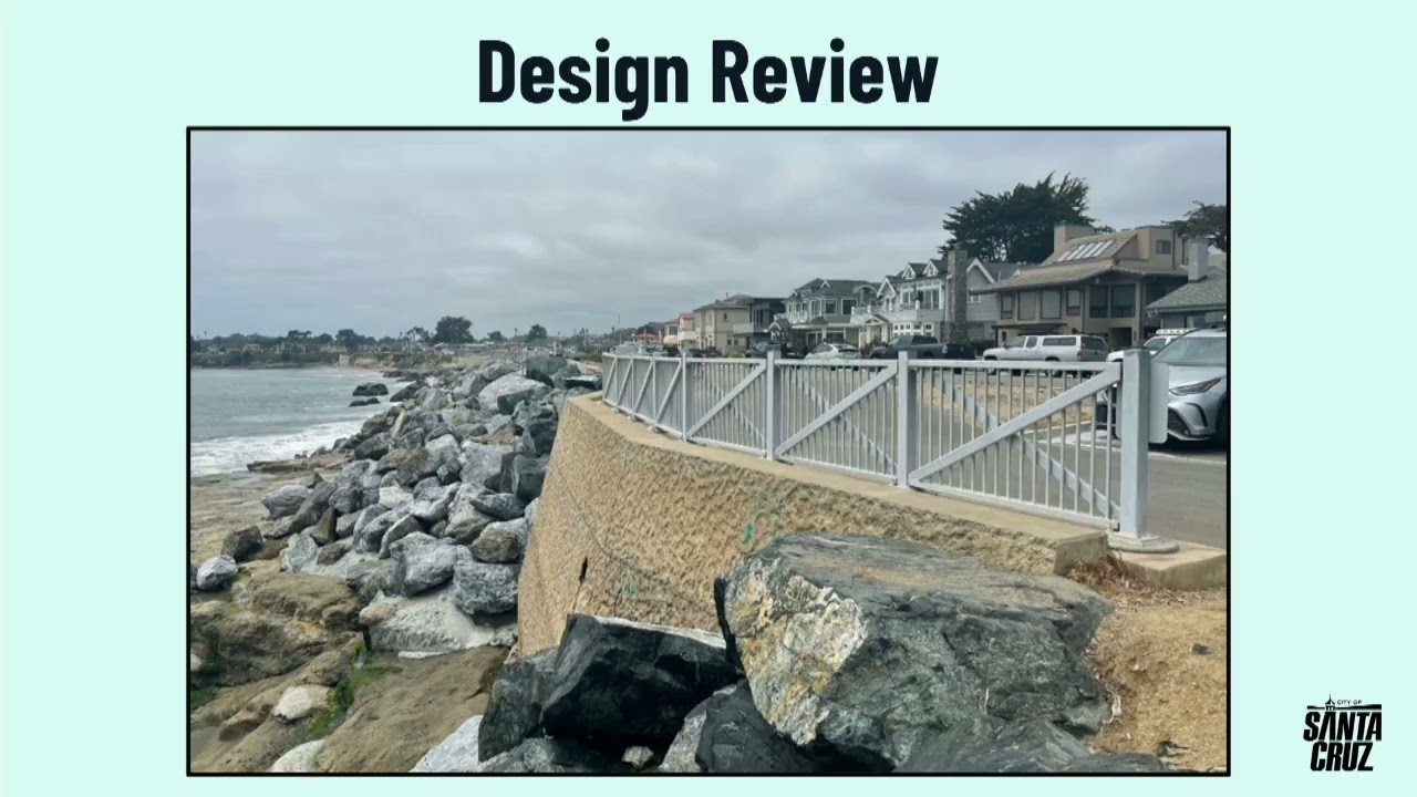
Um so in terms of design review uh the
emergency work primarily consisted of
repairs to the existing infrastructure.
Um but there were new retaining walls
constructed and uh as you can see in
this picture those retaining walls were
textured and colored to resemble the uh
immediately adjacent natural cliffs and
bluffs. Um and that design choice was
intended to help integrate these
hardscape features into the natural
environment.
Um, also with the Bethany C uh Culvert
um replacement,
uh, public works is proposing mosaic
panels to be attached to that bridge.
Um, but city design review is not
required for public art. Um, but the
coastal commission has determined that
those improvements uh would be reviewed
with the coastal permit process absent
this um, no city process for approval.
Um staff has received some public
comments that um some areas within the
emergency repair site um have rebar that
is sticking out from some of the rocks
and some of the concrete um posing a a
public safety uh safety hazard. and uh
public works staff intends to have the
project contractor come out and locate
and cap those pieces of rebar um to
minimize the safety hazards associated
with it.
Um and also staff has received public
comments about um some of the
consequences that can arise from coastal
armoring.
Um, so retaining walls and the like have
the potential to reduce uh beach widths
and also shift uh where sand is in
relation to the beach and the coast. Um,
and so as part of the coastal permit
review uh with the California Coastal
Commission, public works staff is going
to uh work to mitigate those uh impacts
to sand. that could potentially um
um include um removal of unnecessary rip
prep or payment of a sands mitigation in
Luffy. Um but that's still being
actively discussed amongst um public
works and the coastal commission uh for
approval at a a later public hearing.
And in terms of design review for the
road realignment, um it primarily
consists of atgrade structures which
don't add uh visual impact to the
surrounding area. Um and the project
will be built to public works standard
details um ensuring vis uh visual and
physical compatibility with adjacent
road conditions.
Um the project proposes to remove the
temporary plastic and chain link jersey
barriers that are currently on site and
replace them with uh redwood um visually
permeable fencing more in character with
the surrounding area.
Um and also the road portion of this
project is designed to be outside of the
anticipated
100year um erosion area. Um, and then
the multi-use path is designed to be
located out of the 50-year erosion area.
Um, and that's documented by the project
geotechnical report which um created
these like dashed lines showing um
potentially where the coast could erode
in the future.
In terms of sensitive habitat, uh during
the Brethony Bethany curve bridge work,
the CI the city identified that there
was sensitive riparian habitat in the
construction area. And so the public
works department obtained a uh biotic
report and followed its recommendations
during construction that involved a
workers environmental uh awareness
program as well as preconstruction uh
monitoring for um birds and other
sensitive um species. And over the
course of construction, uh the monitors
didn't identify any um sensitive species
or um plants that were in the project
area. So construction concluded without
impacting them.
Then also throughout the emergency
repair sites, uh public works planted
approximately
uh 14,000 square feet of native plants
to reveate the areas impacted by
construction.
And uh with regard to the road
realignment, uh the biotic report
identified that the project site um is
within um sensitive habitat for nesting
birds, roosting bats, and overwintering
monarch butterflies.
And um a initial study was proposed for
this project um which uh drafted
mitigation measures to reduce impacts to
these uh sensitive species to um less
than significant levels. Um so this
takes the form of pre-construction
surveys um avoidance procedures to limit
u that habitat impact during
construction as well as limiting the
times that um the monterey cypress trees
are pruned um so that um overwintering
monarch butterfly habitat isn't
disturbed.
Uh with respect to archaeological
resources, uh during the Bethany curve
uh construction work, um an
archaeological monitor was on site over
the course of construction and they uh
did uncover three historical artifacts.
Two glass bottles um or two of those
being glass bottles and one of them
being a fairly large uh disused trolley
rail segment. Um and the uh
archaeologists determined that these
findings were isolated and um relatively
disturbed. Um so they didn't qualify for
any listing on state or national
historic registers.
>> Am I remembering right that that used to
be a trolley line? Like there's a sign
there. Okay, thank you.
>> Yeah, there was a a trolley line that
ran cool.
>> Pretty interesting. Um and with regards
to the road realignment portion of the
project, it's on sacred lands for the
Costaan Aloney Romson Mutson tribe and
uh archival research um and a site
evaluation showed that the potential to
impact those resources is relatively low
with grading activity. Um but the it's
still a possibility. Um so the
um planning department created
mitigation measures to establish clear
procedures in case that um the
archaeological or tribal resources are
found over the course of construction.
And so getting to the end here, uh, in
terms of SQA review, um, all of the
emergency construction work qualifies
for a statutory exemption from SQA. Um,
because all of this work was performed
in response to a declared California
state disaster. Um and the road
realignment project, an initial study
was prepared and through that document,
the city identified that there could
potentially be significant impacts on
the environment with respect to the
archaeological and um tribal cultural
and biotic resources that I talked about
previously.
And so the city further evaluated um
that mitigation measures could be
created to reduce those impacts to a
less than significant level um which was
discussed earlier in this presentation.
So on the slide right now are the uh two
recommendations that the planning
department is proposing for the planning
commission. Thank you.
>> Right. Thank you for your presentation.
Does any commissioners have any
clarifying questions? they would like to
ask staff before we open.
>> Yeah, go ahead.
>> At risk of touching a sore nerve, can
you tell me a little bit more about the
mosaic thing there? The mosaics are
planned, but because they're on the
coastal commission part of the bluff,
approval goes straight to coastal. Like,
is that weird? It sounds weird.
>> Yeah, I think the city doesn't have a
precedent of processing design permits
or slope variances for public art. Um
but um in the local coastal program
there's language that um
essentially development is defined very
broadly in the local coastal program.
>> Okay.
>> Um and it's more broad than what the
city defines as development. So the
coastal commission decided to take on
the review
that specific project feature.
>> Interesting. Does that mean it's more or
less likely to happen or it's just it's
just a different reviewing body? I'm
just thinking like from a local
perspective if I live on West Cliff and
I want to have some input there. It's a
little bit weird
or you maybe that's not an appropriate
question. I'm not sure.
>> Yeah, I think um so the coastal
commission will be holding a public
hearing for
this improvement um probably in in the
coming months at least before the end of
the year. Okay. Um, and I do know that
there are um
um
there are
like bodies that are like disseminating
information regarding the mural. So
>> cool. That's excellent explanation.
Thank you. Those are all my questions.
Great presentation.
>> All right, I'll go next and then we'll
go down the line. Um, all right. So my
question is that you mentioned the
50-year community plan vision plan. Is
is that my correction? I'm assuming that
>> uh I think I mentioned the 50-year um
erosion area.
>> Okay, cool. So in aligning with that um
do these projects also illustrates um
like how we're considering tonight fits
into that long-term vision on
Westcliffe? Yes, the uh Westcliffe
adaptation management plan um
incentivizes that future projects um
advocate for managed coastal retreat as
compared to coastal armoring. So the
city's intent is to be proactive
um in bringing the road and the rights
of way beyond these erosion areas. Um
and actually in the West Cliff Drive um
adaptation management plan um that
section of Lighthouse Field is
identified as one of the highest erosion
areas. Um in so that's why it was
preferenced um to be relocated um
earlier than some of the other sections
of road.
>> Uh do any of the designs that we're
approving tonight constrain or make
future implementation of a vision more
difficult?
Um,
Kevin, thank you.
>> Thank you.
>> Good evening, Kevin Crossley with public
works, city engineer. Um, it's a pretty
broad question. I'm hoping you can kind
of narrow things down for me so I can
give you a more specific response.
>> Fair enough. So between the five-year
road map and the 50 uh 50y year vision
plan, we're trying to basically separate
pedestrians and cyclists, which I
believe RTC also made that comment in
the report. Um so how are we
aggressively making sure that we're
aligning with those goals that are
rapidly approaching?
Um, I would maybe nuance the answer with
first saying that uh we heard a lot of
community input about the desire to
improve safety along Westcliff uh for
all modes of transportation. Uh
separating cyclists and um pedestrians
uh is is one way you can do that.
Although we didn't have a specific uh
project in the five-year plan to to do
that. Uh we're currently working on um
the shoreline adaptation and management
planning process which is uh another uh
community opportunity to to voice
opinions about priorities and projects
along the coastline and uh definitely uh
enhanced pedestrian safety uh for all
modes is one of the things that we've
heard a lot from the community about. Um
and uh potentially piloting different
roadway configurations is in the mix of
things that may be an outcome of that uh
adaptation and management plan process
that's underway right now.
>> All right. Thank you. Um would you say
that this plan is a more aggressive
version of getting to that uh vision or
is this kind of somewhere moderate?
Um, I think in particular the roadway uh
realignment uh represents the city's
commitment to trying to uh do things
other than armoring where uh the
opportunities are there. And so yeah,
what we're trying to do is present a
balanced approach here. Um 50% of West
Cliff is armored currently and so that's
a condition we're going to be living
with. Excuse me. Sorry for the feedback.
Um but uh in the case with Lighthouse
Field, there's a great opportunity to to
do something different. Um, and so we're
really trying to maximize um the
longevity of the improvements we're
proposing here tonight so that we're not
having to come back and fix the road in
another 10 or 20 years.
>> All right. Thank you.
>> Go ahead.
>> Perhaps a question for you. I'm not
sure. In figure three uh of the report,
there is an alignment shown for what
appears to be the pedestrian and bicycle
uh path and then the road path. I'm just
curious as to the reason for the
separation
at a point where it appears to push the
path further out beyond the hundred-year
uh line. Is there a technical reason for
that or is it is it a design focus or
>> just to get everybody oriented maybe you
can back up. John, do you know which
figure he's referring to? It's one of
the design drawings.
>> Yeah.
>> Yeah. I can talk us through that. Um
here let's go to a uh well this one
works because it's got the erosion
projections. So um we were trying to
accomplish a couple different things
here. Um first of all we're working with
the geometry limitations of a road and
so the road has to account for the
turning radiuses of vehicles. So roadway
design has pretty prescriptive you know
minimum bends and things like that you
have to work with. Um so that's what
governed the layout of the road
basically. Uh the path we had more
flexibility with. Um so we uh looked at
a couple different layouts and ended up
with this one because for starters we
were trying to uh reconnect the path um
by the parking lot in an area that
didn't conflict with a couple of mature
trees that are there. And so we had to
either go um on the oceanside or um uh
inland of those trees which would have
created quite an awkward connection uh
and required removal of parking in a
parking lot the city doesn't actually
own. that's a state parks managed
parking lot. So, in part, we were just
trying to land the path back to where it
um previously was uh while also pushing
it back as far as we could and not
having it run behind the back curb of
the road. Um it's not a very nice
experience to be walking right next to
the road. So, we wanted to leave um a
sort of planted strip between the path
and and the roadway. I'm just asking
because I walk there very often and a
lot of the space
is, you know, the the the edge of the
path is concurrent with the curb.
>> Yeah.
>> And I'm just looking at that one space
where the that's created between the
path and the road on the west end
>> and and uh see just kind of thinking
that that could happen a little later. I
realize it's a little longer along the
road, but it it does appear to cross
quite far over the um the boundaries of
the different timelines of the erosion.
So anyway, I just I I understand what
you're saying. Um
I just are is this leading to a lot more
expense in the the design and the
construction of that or is it is it uh
pretty much level ground? we're just
going to have to do it sooner
if there's a repair that has to be done.
>> Um,
we tried to tie the path in behind areas
that are armored, which means that those
erosion projections are relatively
fixed. That's why all three of the 50,
75, and 100year erosion projections all
converge there on the west side of the
screen. Okay. All right. Thanks.
When I first looked at this, um I was
trying to understand the um uh shape of
the road and its distance, but I think
you've covered that well. I'm um I'm I'm
convinced that um uh it it makes sense
to push the road back for the reasons
that you laid out that u it um is less
likely to require armoring to protect
the road. And so, um, it makes sense to
me now. And, and, um, I think the fact
that we might be able to have a
pedestrian bicycle, um, path that's
closer to the bluff is nice. Um, but,
um, I think the roads in the right
place, and I'm I'm comfortable with that
now.
>> All right. Any other questions from
commissioners?
All right. Thank you so much. All right.
I am at this time I'll go ahead and open
in um public comment. Uh anyone who
wishes to speak on item three or four
tonight, please go ahead and line up to
um uh your right, my left. Um
all right, if you could sign in as well,
that helps us with our minutes.
Thank you. Go ahead and state your name
and then you'll have three minutes to
make your comment.
>> This the presentation.
>> Oh, listen.
>> And thanks for waiting for us for 15
minutes. Appreciate that.
>> No problem.
>> Uh, hi. I'm Benny Benny Dresser. Uh, I'm
a published ecological scientist with a
BS from UCSB. I'm a lifelong Santa Cruz
resident as well. Next slide. And this
here is a stunning image of the very
location that I will be speaking about
today
many years ago. I'm a surfer and
important for day today I am a boogie
boarder as well. I have, like other
boogie boarders, closely monitored sand
movement all along Westcliffe Drive and
the West Cliff um natural coastline
throughout my entire adult life because
doing so is essential for the enjoyment
of our sport.
I'm here today to mention that there is
some more work to be done with regards
to the closest aspect to the shore at um
a world surf heritage world surf reserve
site. Um there was good work done at the
road level, but emergency repairs
nearest to the shore were shoddy in my
opinion and need to be cleaned up. Um
right here is some geoexile that should
not have been used this close to the
shore. That's marine pollution waiting
to happen. Next slide, please. We've
already uh had the rebar issue spoken
to. I thank you very much for getting
ahead of that. So let's just click
through these slides.
Yeah, that's a personal injury lawsuit
waiting to happen. Uh let's stop here.
Um we can see that there is next slide.
Um soft rock at this area. This is a
beach access point. You can see a
footprint there in the foreground. The
rock is eroding faster than the cement.
So the cement's um over time going to
get undercut and then break underfoot
and fall into the ocean. Um just a point
I want to bring up while I'm here today.
Next slide. So, my main point today
though is about the rip wrap. My main
request is that the displaced rip wrap
at this location be relocated. Instead
of reststacking the rip wrap like
beachgoers and boogie boarders have
requested the city to do in the past
while the road was closed, additional
rocks were instead piled on top, further
pushing existing rip rub onto the beach.
Uh why did this choice happen? It's
rather shortsighted. Every new rock that
is placed on the cliff will eventually
roll downhill into the beach and into
the water edge recreation zone. A bigger
pile is a bigger mess in the making and
gravity and entropy conspiring together
will never be fully overcome by human
design, no matter how ingenious.
Next slide. We're going to introduce
some scale bars with reference to the
the um structural awning there in pink.
Fawn rip wrap is a hazard to beachgoers
and boogie boarders because of dangerous
submerged rocks in the waiting and wave
riding zone. It is substantially
impacted. The quality consistency of
this um rare type of beach break, a
world surf reserve wave that is these
kinds of waves um wedging waves along
the coastline are extremely uncommon and
precious. Um what was once a clean wide
open barrel is now a jolting backwash
mess ending in a field of sharp
tombstones. On the now rare ridable
days, waves that were once beautiful
rides now require grit teeth, daredevil
behavior, and the tempting of fate. I've
been rolled over rocks myself, ending my
session. It's not pleasant out there.
For all beachgoers exit exiting the
water, this is anybody on the beach. Um,
these are dog walking beaches uh in peak
summer sand days. Um, exiting the water,
crossing between coes at rising tides is
now much more dangerous because of the
progression of the rip wrap. Next slide,
please. In green, we're going to see a
reference amount of sand. Uh, lots of
variability there over time and due to
just natural variation. Next slide. Uh,
red is going to be rip wrap. This is
2020. Next slide.
2021. No sand on the beach this year
when the photo was taken. Next slide.
Uh, the wave event. Uh, you can see the
waves pulled the rip wrap out to the
east. Um this is where uh wave riders
will exit barreling waves. Next slide.
Adding rocks on top pushed more rocks
even further to meet that protrusion of
rock onto the wave riding and beach
crossing area. Next slide. Um this is
now even further into the future almost
uh this is 2025. Next slide. Lots of
beach area. Still plenty of rocks in the
beach crossing and wave exiting zone.
Uh we I'm here to request that rock
relocation should be done next May uh
after the coming El Nino winter ends. Um
it would be great to please begin
budgeting for this work. Um now uh and
please solicit the boogie boarding and
beach waiting beachgoing community's
advice on how relocation can happen.
We've we've come to the city planning
commission many times in the past about
this subject. um we have yet to see our
um voice become action.
Um coastal management that works with
the forces of nature and seeks to
support the longevity of precious waves
such as this one um is uh how I see uh
the planning commission going in the
future and I applaud that. Um let's take
that and turn it into real action on the
ground. Thank you so much.
>> Thank you for your comment.
All right, next president.
Go ahead and state your name and then
you'll have three minutes for your
comment.
>> My name is David Curley.
>> Parks are precious. Please don't pave
them. Realignment provides no safety
nets. Clipsy road then snatch more park
from wildlife descendants leashed pets.
Lighthouse Field rescued in the 70s from
high-rise dwelling shopping mall enjoyed
by wildlife and their watchers. Historic
cypresses need not fall.
Redtailed hawk feeds her fledglings
yearly nest. Vast open space. Great
horned owlet now lives here majestically
monitoring the whole place.
Mama coyote wanders
hunts raises pups in park den nearby
raccoon family gathers
compost bin d dining dining after 10
rainy season frogs in the meadow massive
chirp chorus into night hidden but
present ever rejoicing let's not worsen
their plight luxury homes lining
westcliffe coastal wall keeps them dry.
In park realignment really necessary.
No alternate options apply.
Bulging 700page project plan. Westcliffe
wanderers unaware. More public outreach
signs and pictures might help understand
if they care. Lighthouse Field State
Beach Park restoration improvements made
it glisten. Project zone marked planning
in planting in progress. Let's not plant
asphalt. Please listen. Dividing monarch
dwindling monarch migrants soon join us.
Overwintering sight vital out west.
Roost feed mate throughout park. Cypress
protection they like best.
Vibrant park treasure to be savored.
Nestled right here near Midtown. Please
enjoy and preserve it without tearing it
down. Every surfer, bird watcher, biker,
every jogger, walker, critter deserves
to bask in parks glow. Disco ball
dancing with glitter. Once paved,
recover recovery unlikely. Offseason
construction does not help. Let's
preserve it for generations. Please heed
my collective loud yelp. Thank you very
much.
>> Thank you for your comment.
>> Would anyone else like to come up to the
podium and speak on these items tonight?
All right. Seeing none, would staff like
to address any of the issues or
concerns?
>> Yes. Um, in regards to the first
presentation, um, I think public works
can speak to this a little bit more. Um
but as part of the coastal permit
process um the relocation of rip wrap
and payment of potential uh sand
mitigation fees I believe is on the
table. Um I think Kevin could probably
speak more about it.
Uh yeah. So I think it's worth noting
that um I think an upshot of the seaw
walls was that we took up quite a bit of
rock out of that area. Um without before
and after photos, it's hard to visualize
that, but there was quite a bit of
armoring that um after the emergency
storms uh was still left. And so we did
take as much as we could uh easily
access with the equipment and um means
that we had at our disposal at that
time. Uh it's quite uh challenging to um
pull rock once it's been displaced and
in the sort of surf zone or submerged
underwater. So uh that's an ongoing
process we're continuing to work on. Uh
another compounding factor for us was
that uh we applied for um FEMA money uh
when the emergencies originally happened
and we were actually denied uh all the
funding requests that we submitted to
FEMA. So that really put us at a
disadvantage from a a resource
standpoint to deal with some of the um
rock um that had been displaced that we
would have liked to have dealt with um
right after the storm events. So, we're
continuing to try to chase down funding
to do that. It's a it's a very expensive
proposition to um go fish rock out of
the ocean. Um but it's a important thing
that we hear a lot about from the
community, the regulators. Um it's going
to be a feature in one way, shape, or
form of the um coastal permits that we
hopefully um go to the board with
coastal commission in the next couple of
months.
>> While you're there, can I ask a quick
question? I'm on the sustainability and
resiliency committee. So, we just
reviewed that plan that I'm blanking on
the name of for Westcliffe. And I
learned that like rip wrap lasts like 30
years generally speaking. Is that a good
rule of thumb or you know, I'm sure it's
different here or there depending on
where the waves hit. But, uh it was I
was like, "Oh man, it only lasts 30
years and then you got to redo it every
time." So
>> yeah, we uh we inventoried all the rip
wrap along the coastline in 2019 and
gave it a lifespan of 0 to 30 years was
the the time frames assigned and it's
really heavily dependent on the
orientation of the coastline to the wave
attack and
>> uh what size rock was used originally.
Some of the oldest rip wrap is actually
at Cow's Beach and it's some of the, you
know, best condition because of the fact
that it's in a cove and it's not
>> getting hammered like some of the other
spots along Westcliff.
>> Okay. And just underscored for me how
it's like mowing your lawn or pulling
weeds. It's just like a constant
management process down there.
>> Yeah.
>> All right. Thank you. All right. Um,
anyone else need to make a comment
before I close? All right. I'm going to
close oral communications and bring it
back to the commission for item three.
Um
item three is basically um as we see we
can see here the emergency repairs
CP26-0092.
So I want to just chime in and uh
like really salute the city for this
process. There's so many o overlapping
layers of input and you know going back
to the emergency plans and all this
climate action stuff is feathering in
here. So um I don't know if anyone here
is feeling it but there's often this
feeling of like oh where did this come
from? We didn't get a chance to get our
um comments in. And I want to say that
was incredible public comment. Thank you
for the work on that. I appreciated it.
Um, so I just wanted to encourage the
public to keep emailing Tiffany and
going to the website and, you know,
putting your voice out there. Your voice
is really heard. It's really true. I
mean, we all feel, I think, unique
passions for Westcliffe. I know I do.
Um, I think of all the memories in those
parking lots, you know, when I was in
high school and just these wonderful
things. So, um I wanted to reassure and
emphasize the care that the city's taken
with this process and the kind of um how
great it is to have this community
process ahead of time. So, when we look
at these emergency reactions, we really
have a guide book for not what everybody
wants, but kind of how everyone's
feeling about this stuff. So, um I just
wanted to say that and I think this is
excellent project and have no qualms
about making a motion to support it. Um,
there's a lot of parts, but it sounds
like our discretion is pretty limited
here. So, I'd love to talk about public
art plans and all these other wonderful
things, but let's let's get this through
and let those other processes happen
because they totally are.
>> Any other commissions would like to
speak?
No, I I would uh applaud the work that
the city staff has done on this and I
have the opportunity to work in other
communities and I can't picture any of
those communities having put the kind of
thought and care and enlightened
engineering
bringing to bear on this. So
support
>> yeah I definitely support the overall
direction that uh the manage retreat is
here. It's been great seeing that um the
real time care into these projects.
Anyone want to support a motion?
>> I'll go ahead and move to approve item
three.
>> A second.
>> All right. Can I make a friendly
amendment? Absolutely.
>> The friendly amendment is I'd like to
offer um to direct staff where feasible
within the approved project scope to
incorporate improvements identified in
the current Westcliffe road map that
advances the 50-year community vision,
particularly improvements that
facilitate the future separation of
pedestrian and um bicycle travel.
>> Sounds great to me. Uh staff, any
objection to that language?
There's a second approve of amendment.
All right, we can go ahead and do a roll
call vote.
>> Commissioner Kennedy
>> here.
>> Melby.
>> I me.
>> Thompson
>> I.
>> Chair Kelly
>> I. All right, that motion uh passes. And
now we can go ahead and move to item
four. Um item four is the road
realignment CP26-000077.
Unless there's further discussion, I'd
be happy to move approval of item four.
And would you like with with the
friendly amendment language just baked
in the first time?
>> Yeah, I'll second that. I'm I'm was um
uh concerned about it um originally, but
I I see the point and I support it.
One more quick item of discussion. I was
down there today and saw um Mike
Rockkins memorial is up in the midst of
concrete bunkers and sand flying. And I
just uh so appreciate his leadership
when he was here with us. And isn't that
Santa Cruz sand strong amidst all the
rocks and things? So it just made me
happy to see that there. And I'm h I'm
sure it'll be located relocated to a
great spot.
Do we have a second motion?
>> I think I second.
>> You seconded. Okay, perfect. So, if uh
there are no further comments, we can go
ahead and do a roll call vote.
>> Mr. Kennedy,
>> I.
>> McKelby,
>> I.
>> Thompson,
>> I.
>> Chair Kelly,
>> I. All right, that one passes.
All right, that concludes all the items
um on tonight's agenda and we'll now
move into information items.
Uh staff, do we have anyformational
items for tonight?
>> Yes. Sorry. Um I do have a couple of
updates for you. So, excuse me. Um on
August 11th, the project at 900 High
Street was approved by the city council.
So, that is a housing project that's um
up behind the Peace United Church on
High Street.
Um, and then we do have some stuff
coming before you in the coming months.
Actually, I only have one thing to
report that's coming before you in the
coming months. So, September, we have a
zoning update package. Um, so that will
be some
uh less
I guess kind of a cleanup package, but
um to get the code in line with state
law and with um some elements of the
climate action plan,
>> the yearly
>> Yeah.
>> Which is a good thing. Yeah.
>> Um and then we did have a community
meeting last night for the project at
1501 through 1511 Mission Street. So
that went very well. We had about 30
attendees and um the architect was there
and received a lot of comments about
different design options and also heard
some concerns um I would say primarily
about traffic and the need for
pedestrian improvements um along at the
bay mission intersection.
>> So Tresany is the cross street right
there.
>> Yes, Tresany is the the exterior side.
>> Yeah, an early intersection.
Um, and then finally, we have a design
guidelines guidelines survey that's open
through the end of August. And so, we're
encouraging the community to go to that
web page and fill out a survey and um,
get some input on that.
>> I don't want to brag, but I've talked
six people into doing it. And they
actually did it.
>> Step up. You guys,
>> I've heard quite a lot of people say
that the direct both encouraging other
people to go and also done it
themselves. So, hopefully it's going to
pan out. I heard that you had 60
responses.
>> Oh, nice.
>> Great. Excellent. The more the better.
>> Yep. That's That's
>> I had a a quick question on the project
um up on um uh by the church up behind
the church. Um uh just curious why it
didn't come back to the planning
commission. It just was heard by the
council.
>> Yes. So, that was a project that was
heard by the planning commission and
then and then I think it was appealed to
the No, no, I'm sorry. It went to the
city council for final approval and then
I think it was
No, it was appealed to the city council
after the planning commission approval.
Um, so now that it came back in, it
wasn't technically a new project. It was
a major modification to the original
project. So, um, because it's a
modification, it just needs to be heard
by the hear by the hearing body who
approved the original project.
>> It was a substantial change. So, I was
surprised that it didn't come back to
us. But that makes sense,
>> you know.
>> Yeah, it is. It is major modifications
are sort of substantial changes. We have
to make the all the findings again
whereas like a minor modification, we
just have to make limited findings. Um,
so yeah, there were a lot of changes.
>> It it only occurred to me because it was
a really substantial change. So for the
better, but um still it was um it wasn't
a small tweak. It was a big deal.
>> All right. Thank you. All right. I guess
we'll move to some committee and advisor
body oral reports.
>> We had another meeting of the
sustainability and resiliency
subcommittee. It's going great. We
reviewed all these Westcliffe adaptation
plans. Oh, the level of like technical
detail and engineers and then all this,
like I said earlier, like the emotion of
everyone about West Cliff. It's just
quite a process. But, um, it's like
thrilling. We're ahead of everyone else.
And essentially, it's going to cost so
much money that we just have to be like
first in to get all this money from
above. And boy, are we well positioned
for that at
>> or a different state perhaps?
>> Who knows? Who knows? But um we'll be
ready to catch that money whenever it
comes.
>> It it was heartening. It was really
nice. On the downside, we scheduled a
meeting when one of our members who's in
high school was in class because we
couldn't find a room. And I'm just like,
>> "All right, so the climate voice that
we're not going to hear is the high
school student." And that's okay. I
understand staff. I know scheduling and
noticing and the Brown Act these. But I
was just like, "What the hell? We're
never going to solve this place in the
room." So, I just wanted to express that
and let it go. Um, good committee. Maybe
it will continue. We're not sure.
>> All right. Anyone else? Awesome. Um, and
you covered items on future agenda
items, so I think we can go ahead and
join.
>> Thank you, everyone.
>> You
just parking lot on
that.